Washington’s Roadless Forests
by: Washington Wilderness Coalition Posted on: October 21, 2010
August 11 proved to be anything but a typical day for two staff members from Washington Wilderness Coalition. This would not be a day of office work and phone calls in the name of wilderness conservation. Instead, the staffers took to the sky in two single engine planes with volunteer pilots and a King 5 NBC TV news crew to get a birds eye view of some of the places they work so hard to protect.
The flyover was part of an event called National Roadless Recreation Week. Only 2 million acres of these places, known as roadless areas, remain in Washington State. While outdoor enthusiasts may unknowingly stumble into them on a day hike or while kayaking on a summer afternoon, most don’t know their true importance.
Washington State is home to the 9th largest roadless acreage in the U.S. But these areas are more than just open land. For communities like Port Townsend on the Olympic Peninsula and Everett, north of Seattle, roadless areas mean the purest source of municipal drinking water. According to the Natural Resources Defense Council, 60 million American’s count on roadless areas for their clean drinking water. For outdoor enthusiasts in southern Washington, the Dark Divide roadless area provides ample hiking opportunities with breathtaking views of Mount St. Helens and Mt. Adams. And in eastern Washington, the Thirteen-Mile and Profanity roadless areas in the Kettle Range are home to grizzly and black bears, wolverine, cougar, lynx, elk, mountain goat and trout. Roadless areas also offer opportunities to horseback ride, cross country ski, kayak, raft and more.
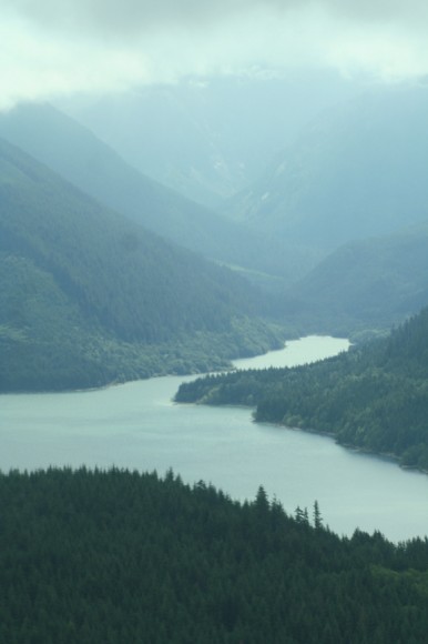
WWC staffers were able to see examples of these connections first hand during the flight over a portion of the central Cascades. Flying over Spada Lake, the source of water for most of Snohomish County, it was easy to map the water as it flowed to the lake from its source in the Glacer Peak K roadless area. Turning north, the crew headed toward Darrington, a town built near the Stillaguamish River and the Mount Higgins roadless area. Along the way, countless farms dotted the terrain, with various creeks, rivers, and tributaries flowing nearby. Again, the importance of clean water was made, this time in connection with irrigation and farming.
Following the river west, the connection became even clearer as the crew approached the deltas at the Puget Sound headwaters. As the struggle continues to cleanup Puget Sound, it became clear one way to do so is by maintaining a clean system further up river.
For Washington Wilderness Coalition, these connections are obvious. But the message hasn’t been one easily received. In 2001, the Forest Service issued the Roadless Area Conservation Rule, an effort meant to protect these pristine places from road building, logging and mining. During his term, former President George W. Bush attempted to alter the rule, allowing state’s the authority to determine roadless areas. The attempt was eventually overruled by the courts. Last year, the Obama administration announced a one year review process of the Forest Service Rule. Now, the process is awaiting a ruling by the 10th circuit court.
As groups across the country await the much anticipated decision, they’re asking people to continue to push for roadless protection. Washington Wilderness has been working to generate support for the 2001 rule. In Washington State alone, more than 200 local elected officials, 90 religious leaders and more than 70 local stakeholders including hunting, fishing, and recreation groups, have signed on to support the Roadless Rule.
Articles On Flora
Flora: Flora
- Apr 1 Big or Small: Who Will Grow Washington’s Cannabis Crop?
- Jul 19 A Case to Protect Public Land
- Apr 6 Oregon is a Desert State
- Dec 14 Forest Protection-The Olympic Peninsula
- Nov 30 Keeping Working Forests on the Landscape
- Nov 2 It’s a Wild Life – Can You Spare Some Passion?
- Sep 28 West Hylebos Wetlands: A Place Worth Preserving
- Aug 8 12,000 Rain Gardens
- Jul 11 Investing in Seed Banks
- Oct 21 Native Plant Spotlight: Oregon Grape
- Oct 21 Washington’s Roadless Forests

