Historical Climate Trends in WA and Future Change
by: WA State Climatologist Posted on: October 29, 2012
By The Office of the WA State Climatologist (OWSC)
Editor’s Note: Below you’ll find a resource for understanding climate change science and hints on how we can adapt to Washington’s changing climate. Written by the Office of the WA State Climatologist.
According to the latest Intergovernmental Panel on Climate Change (IPCC) report in 2007, the leading international authority on current climate change science, warming of the global climate is certain. Average global temperatures have increased by 0.74°C (with uncertainty ranging from 0.56-0.92°C) from 1906-2005 (IPCC 2007). An updated IPCC report is due out in 2014 and will undoubtedly reveal further increases in global temperatures and associated consequences. Regional climate trends are often a more complicated story. Climate changes will vary by region, and regional impacts are much harder to predict than those for the globe as a whole.
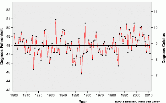
The mean annual temperature averaged over WA from 1900 to 2011 is shown in Figure 1a (above), with the 20th century average plotted in bold. Since the mid-1980s, five years were below the 20th century average, two of which (2011 and 2009) occurred very recently. The warming trend in annual temperatures over the whole period is minimal at 0.06°F (0.03°C) per decade. Annual total precipitation averaged over WA (Figure 1b) features high variability, but also a more defined increasing trend of 0.47 inches per decade. A more localized view of trends throughout WA (and the wider Pacific Northwest) is available by examining individual station records. Temperature, precipitation, and snow water equivalent (defined as the amount of water in snowfall) trends for individual stations are available using an application on the OWSC website. The long-term trends (1895-2010) show warming for most of the WA stations, especially in the overnight low temperatures. Long-term precipitation trends show an increase in precipitation for most WA stations as well. Not surprisingly, these are both similar to statewide average trends shown in Figures 1a and 1b. Trends are very sensitive to the years that are chosen for the endpoints of a record. Caution is advised when looking at trends with dates that may be “cherry-picked” to illustrate a specific point (1895 and 1900 were chosen as start dates here to illustrate long-term trends).
It is important to recognize that the climate is far from static. Just like the weather varies from day to day, the climate fluctuates on time scales ranging from years to decades. These fluctuations are largely intrinsic. In other words, the climate is a chaotic system, and its internal workings can bring about remarkably persistent deviations from long-term (multi-decadal) averages. There are some systematic influences on the seasonal mean weather in the Pacific Northwest, such as El Niño-Southern Oscillation (ENSO). ENSO represents an irregular cycle between phases characterized by relatively warm (El Niño), near-normal (neutral), and cool (La Niña) upper layer ocean temperatures in the central and eastern tropical Pacific. These temperatures relate to the distribution and intensity of areas of thunderstorms, which in turn impacts the global atmospheric circulation. For the Pacific Northwest, on average, La Niña brings wetter and cooler winters while El Niño years bring drier and warmer winters. At the time of this writing (August 2012), models are indicating slightly better than even odds of El Niño conditions developing in the fall, which increases the chances of a warmer and drier than normal winter in WA. ENSO conditions are currently neutral, which is common during the summer months. But aside from ENSO, which we still don’t know how climate change will impact, there is little for us to hang our prediction hats on, again because the climate system creates variability out of thin air (pun intended). For example, there was no indication during the mid-2000s that WA would experience relatively cool conditions during the last few years. The bottom line is that the climate has plenty of tricks up its sleeve, and specific outcomes beyond a year are very difficult to predict.
But this doesn’t mean that climate projections for the region are hopeless. While we cannot predict swings in temperatures, precipitation, storminess, etc. beyond a year or so, projections of trends on multi-decadal time scales are feasible. A variety of climate model simulations have been carried out for the 21st century, and a substantial effort has gone into applying these models towards projections for the Pacific Northwest. A summary of these results was compiled in the Washington Climate Change Impacts Assessment (WACCIA) by the Climate Impacts Group (CIG) of the University of Washington’s Joint Institute for the Study of Atmosphere and Ocean (JISAO), and is available here.
Temperatures in the Pacific Northwest are expected to rise, with typical increases of about 3°F by the 2040s. The projections for precipitation are more nuanced, with many models indicating relatively modest changes in annual total precipitation, but also some tendency towards wetter cool seasons (i.e., winter, spring, and fall) and drier summers. An example of these forecasts is reproduced in Figure 2. It should be noted that the combination of warmer, wetter winters and drier summers would be accompanied by greater flooding in winter and reduced water supplies in summer due to decreases in summer snowmelt. If the seasonality of the weather in the Pacific Northwest indeed undergoes this kind of change, there will be significant implications for sectors ranging from ecosystems to energy, as also summarized in the WACCIA.
Figures:

Figure 1a

Figure 1b
Figure 1a+1b: Average temperature (a) and total precipitation (b) averaged throughout WA State from 1900 through 2011. The thick, black line represents the 20th century average in each plot. Data and plots from the National Climatic Data Center.

Figure 2: The percentage change in seasonal precipitation for two emissions scenarios (B1 and A1B) by the 2040s. Winter is DJF, spring is MAM, summer is JJA, and fall is SON (from Chapter 1: http://cses.washington.edu/cig/res/ia/waccia.shtml).
One Response to “Historical Climate Trends in WA and Future Change”
Articles On Air
Air: Air
- Oct 29 Historical Climate Trends in WA and Future Change
- Aug 5 It’s About More Than Business
- Jun 3 Liquefied Natural Gas Exports? (Part 2)
- May 6 Why Coal?
- Apr 22 Foreign Interests, Local Uranium
- Apr 13 Liquefied Natural Gas Exports? (Part 1)
- Sep 21 Liquified Natural Gas on the Columbia River Reignites Fossil Fuel Battle
- Nov 8 Columbia Gorge Air Quality
- Oct 21 How is YOUR Air Quality?


by: I am trying to locate records of wind velocities and didrectdions inthe vicinity of Bothell Washington. Bill Van Natteron: Thursday 14th of November 2013