A complicated situation: Lake Roosevelt and the Grand Coulee Dam
by: Lake Roosevelt Forum: Andy Dunau Posted on: February 17, 2012
By Andy Dunau, Executive Director of the Lake Roosevelt Forum, President of Dunau Associates, Executive Director for the Spokane River Forum and the Foundation for Water and Energy Education
Editor’s Note: In this piece we are given a valuable perspective and background introduction on the complexities facing Lake Roosevelt, the Grand Coulee Dam and the Columbia River. The reality of the many stakeholders needs to be well understood.
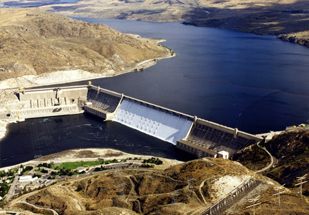
The Columbia River rose up to 400 feet behind Grand Coulee Dam when the gates of the Dam were closed in 1942, creating 600 miles of shoreline. Franklin D. Roosevelt Lake (Lake Roosevelt for short) was created, extending over 150 miles from Grand Coulee Dam to near the Canadian border. Lake Roosevelt is also called the upper Columbia because, naturally, the Columbia did not disappear.
More than sixty years later, Lake Roosevelt and Grand Coulee Dam symbolize the cascading outcomes (intended and unintended) of the bold action and fundamental changes initiated by our forefathers. Regardless of whether you paint these actions as good or bad, this is our reality and the starting point from which tribal governments, elected officials, managers, and citizens are sorting out what the future holds.
Decisions about the operation of Grand Coulee Dam and Lake Roosevelt will affect the entire Pacific Northwest.
Big Lake, Big Money
Lake Roosevelt is the equivalent of an eight-story building that is one half to one mile wide and over one hundred miles long. It can hold over 9,000,000 acre-feet of water. That’s the “box” within which Lake Roosevelt’s operations are managed. Run-off from the Canadian Rockies and tributaries into the lake allows it to refill about seven times in an average water year. By comparison, one of the other large reservoirs in the region, Hungry Horse, could not refill in the same year if it were emptied.
This box can be viewed as a battery for big money operations with outcomes effecting the entire Northwest. Start with flood control. Portland stays dry when the spring melt arrives primarily because Lake Roosevelt is drawn down like a bathtub waiting to be refilled. In a major flood year, like 1996, an estimated 3.2 billion dollars in property damage was avoided.
Now fold in power. The Columbia River has fourteen hydroelectric dams, collectively producing about thirty percent of the Pacific Northwest’s power. As a power manager, you get the most out of this generating capacity by using Lake Roosevelt’s battery (water storage) to regulate when the turbines turn. As people wake, for instance, to take hot showers and blow-dry their hair, more electricity is needed. Since the power grid can’t store electricity, the ability to increase and decrease power by storing and releasing water at projects like Grand Coulee is critical.
Then there are the fish. The Columbia River Biologic Opinion (BiOp), issued by NOAA Fisheries in consultation with other federal agencies, is the blueprint for setting flows to meet the needs of endangered salmon (as required by the Endangered Species Act). By law, it’s flood control and fish flows first, power generation second.
And finally, let’s talk irrigation. Water from Lake Roosevelt is pumped 280 feet up to Banks Lake. 27 miles long, Banks Lake supports the Columbia Basin Irrigation Project. Think that’s not a big deal? Did you know Banks Lake is the largest water reclamation project in the United States, that it irrigates over 670,000 acres, and that the project diverts two to three percent of the water in the Columbia?
Let’s tally up the annual big lake, big money enterprise. The U.S. Bureau of Reclamation estimates Lake Roosevelt leads to $630 million of irrigated crops sold worldwide, $950 million in power production marketed to utilities throughout the west, $20 million in flood damage prevention all the way to Portland, and $50 million in recreational activity each year. From agriculture to downstream power projects, the multiplier effect on our Pacific Northwest economy and way of life is several times more.
Lake Roosevelt Stewardship
But Lake Roosevelt isn’t an eight-story building or a battery. It’s a beautiful, scenic area visited by 1.5 million people a year. Ironically, it’s one of the last largely “untouched” reaches of the Columbia because the majority of shoreline was purchased by the Bureau of Reclamation and is now managed as a National Recreation Area. The remaining shoreline is under the stewardship of the Spokane Tribe of Indians and the Colville Confederated Tribes. The population of communities and tribes surrounding the lake barely constitutes a bedroom community for Seattle.
Because of Grand Coulee Dam, and the construction of Chief Joseph Dam a few miles downstream, salmon no longer migrate through the upper Columbia and into Canada. A way of life has simply been lost. Today only redband trout, kokanee, and white sturgeon provide the genetic and cultural links to the upper Columbia’s nine thousand year history. All are struggling and the focus of restoration efforts.
Using fish as an example, questions of fairness and stewardship are as alive today as when Lake Roosevelt was first created. Take, for example, the BiOp. It protects fish flows for endangered salmon downstream but doesn’t mandate meeting September lake levels to assure kokanee spawning. For Federal Columbia River Power System managers, that’s voluntary.
Then consider choices that must be made by the Northwest Power and Planning Council and Bonneville Power Administration for fish and wildlife funding. The good news is that in the past millions of dollars have been allocated to area tribes, the department of fish and wildlife, and others to mitigate the effects of Lake Roosevelt being in a “blocked” area. These dollars reestablished Lake Roosevelt’s sport fishery and are critical to restoring native fish populations. But as a new round of funding is considered, how will funding for those trying to restore downstream salmon be balanced with those trying to restore and protect what’s left of the fishery in blocked areas to which salmon can no longer migrate?
And let’s consider possible renegotiation of the Columbia River Treaty between the United States and Canada. A key component of the treaty is compensating Canada for holding water in their part of the system. This lets managers jointly “shape” water flows and reservoir levels to maximize flood control and power generation. Starting in 2014, either government can start a ten-year clock to terminate or come up with a new treaty. The outcomes of these decisions can dramatically affect water flows, and therefore the habitat and fishery, of Lake Roosevelt.
Again and again, the question becomes fairness and stewardship. What’s best for the environment and communities of Lake Roosevelt? What’s best for Uncle Sam’s pocket book and power rates? What’s best for endangered fish? What’s best to mitigate lost tribal resources? What’s best for the Columbia Basin Irrigation Project? What’s best for people looking to firm up junior water rights to grow grapes to put wine on our tables? What’s best for creating jobs? What’s best for…
These decisions, all under the name of stewardship, are the waterfalls we hear roar today. Operation of Lake Roosevelt, quietly situated at the top of the Columbia River System in America, will reflect the answers.
2 Responses to “A complicated situation: Lake Roosevelt and the Grand Coulee Dam”
Articles On Water
Water: Water
- May 2 Part 1: Oregon County Faces Gas Industry Funding, Lobbyists in Battle to Halt Jordan Cove LNG Project
- Dec 8 Bottled Water Facility Stopped, Local Government Replaced
- Nov 8 Washington State attempts to sell Columbia River water for $6 million
- Aug 8 USA Refuses to Ban Atrazine
- Aug 8 When Public Utility Districts Forget Who They Serve
- Jul 8 Water Quality, Who Should Decide?
- Jan 14 The Balancing Act: Exploring Water in the Skagit Basin
- Jun 30 Water in the West: Diverse Tools for Conserving our Rivers and Communities
- May 20 Managing Many Waters the Walla Walla Way
- Mar 19 The Clean Water Act – A Story of Activism and Change
- Mar 2 Privatizing a Basic Human Right: Water
- Feb 17 A complicated situation: Lake Roosevelt and the Grand Coulee Dam
- Feb 10 Bottle the Skagit River?
- Nov 20 One Step Back for Clean Water in the Boise River
- Nov 13 If it Ain’t Broke, Don’t Fix It: Portland’s Water System
- Oct 15 Protecting Our Region From Hanford’s Spreading of Contamination and From Being Used (Again) as a National Radioactive Waste Dump
- Sep 15 New Gold Rush Threatens the West
- Jun 2 America’s Antiquated Mining Policy
- Mar 15 Drinking Water in Bellingham and much of Whatcom County
- Nov 26 Thurston County Hydrologic Cycle
- Nov 14 River Watch-Thomas Creek
- Nov 11 Water Wealth
- Oct 21 River Watch-The Teanaway
- Oct 21 Why Conserve Water in the Pacific Northwest?


by: Anna Bakeron: Sunday 26th of February 2012
by: Louise Watsonon: Friday 6th of March 2015